Unveiled: The Enigmatic Global Pulse That Echoed Every 90 Seconds for 9 Days in 2023
Ever wonder what it feels like when the Earth decides to throw a party every 90 seconds for nine straight days? Well, buckle up, because in September 2023, our planet was literally shaking its groove thing, and then—because why not?—it did a repeat performance a month later. Now, while you might think this was just Earth’s way of showing off, a sharp team of scientists from the University of Oxford put on their detective hats and cracked the case. Turns out, it wasn’t just random seismic jazz: mega-tsunamis triggered by warming glaciers and tumbling landslides near East Greenland’s Dickson fjord were to blame, their waves trapped in the fjord like that one friend who never knows when to leave. Thanks to NASA’s shiny new radar-pulse-tech—the Surface Water Ocean Topography (SWOT) satellite—these wild oceanic antics were mapped out in stunning detail. This isn’t just geeky satellite stuff; it’s a game changer, warning us about climate change’s sneaky new extremes while opening a fresh window into the deep blue’s secret chaos. Curious to see how space tech became the planet’s eyes and ears? LEARN MORE
For nine days in September 2023 the world was shook every 90 seconds by a seismic signal, and then a month later the phenomenon repeated itself.
It’s the job of a scientist to get to the bottom of mysterious seismic activity and now, researchers from the University of Oxford have worked out what actually happened.
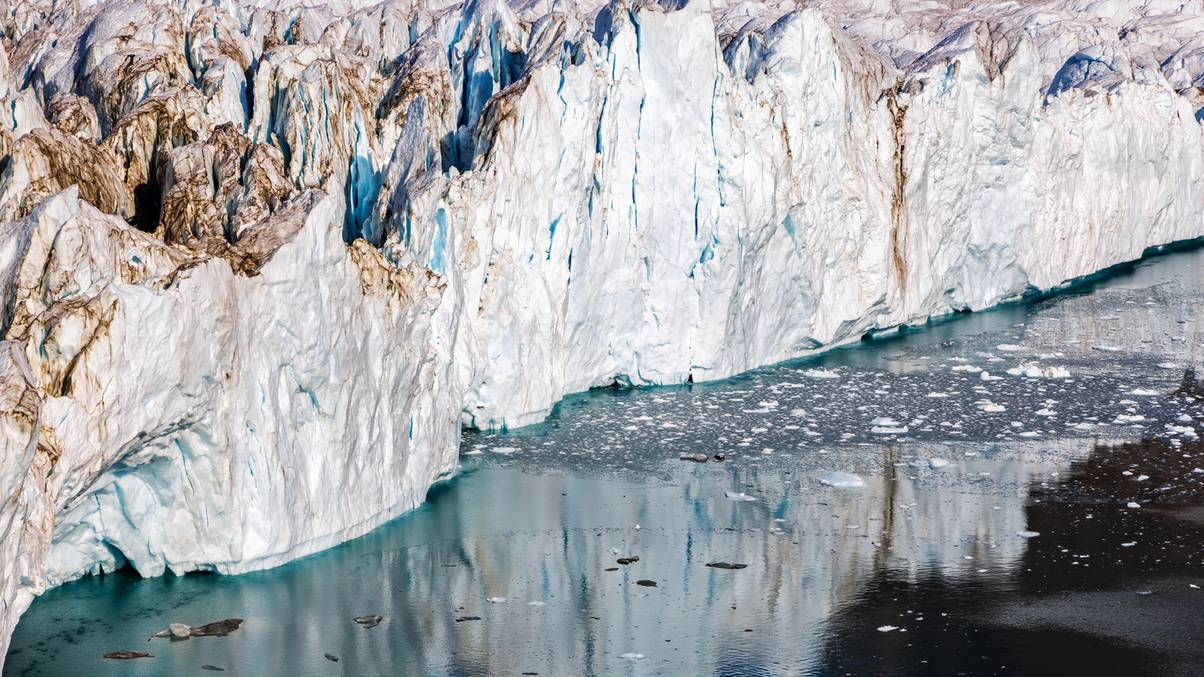
They explained in a release that studies had suggested the cause was a couple of ‘mega-tsunamis’ triggered by a glacier warming and triggering landslides near a Dickson fjord, East Greenland.
The theory suggested that the waves of the mega-tsunami got stuck in the fjord and set off the signals, and now the mystery has been solved.
It’s all thanks to them measuring the height of the Earth’s surface, which includes the ocean, by seeing how long it takes for a radar pulse sent by a NASA satellite to reach the planet and return.
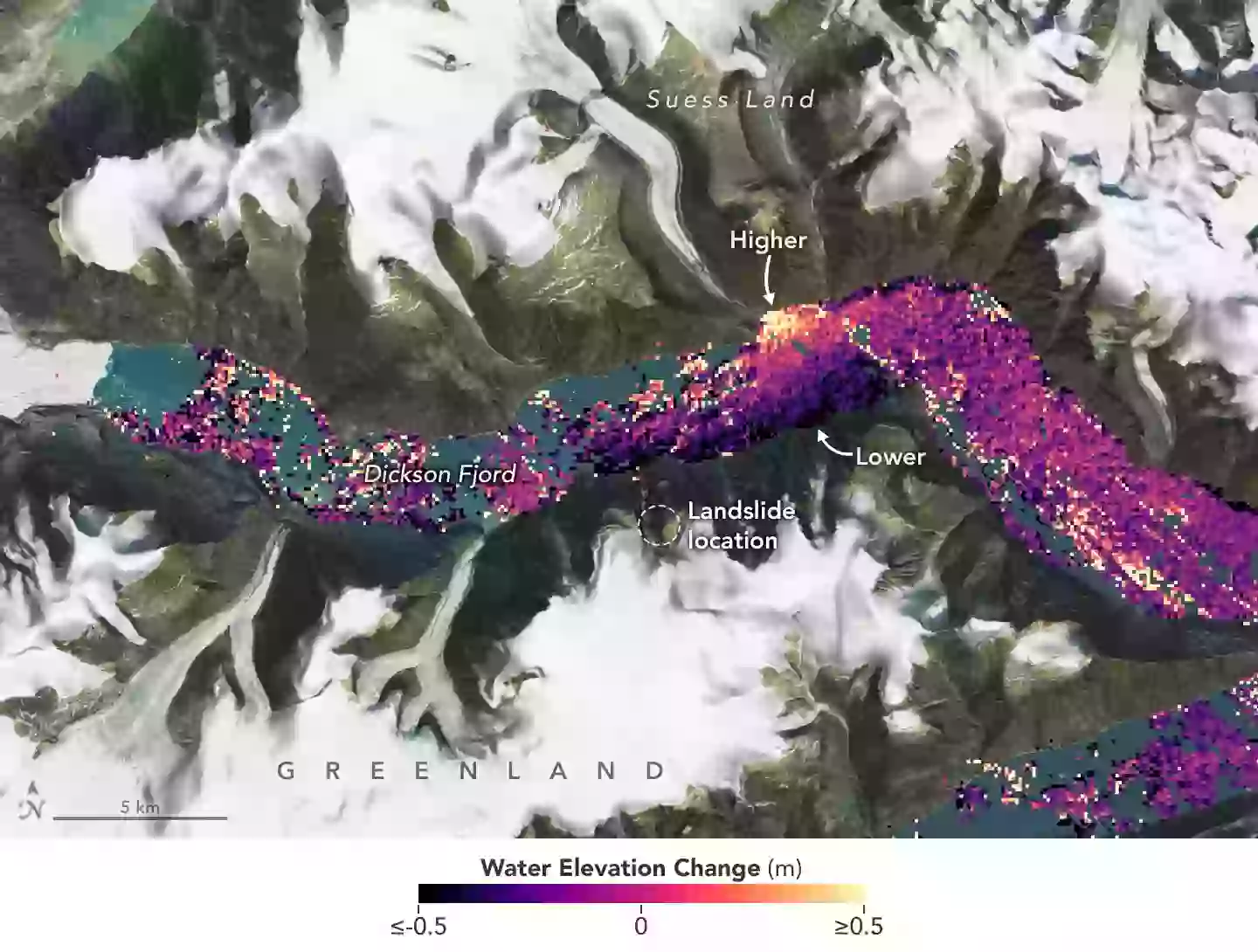
Scientists used a new NASA satellite to work out what happened (NASA)
By doing this the scientists could spot the differences in water height and map out the waves.
Study co-author Thomas Monahan said that data was captured by a Surface Water Ocean Topography (SWOT) satellite and said the technology was a ‘game changer’ in spotting what was going on with the thing that covers about 70 percent of the planet’s surface, and warned of the dangers of climate change.
He said: “Climate change is giving rise to new, unseen extremes. These extremes are changing the fastest in remote areas, such as the Arctic, where our ability to measure them using physical sensors is limited.
“This study shows how we can leverage the next generation of satellite earth observation technologies to study these processes. SWOT is a game changer for studying oceanic processes in regions such as fjords which previous satellites struggled to see into.”
Professor Thomas Adcock, who co-authored the study, added: “This study is an example of how the next generation of satellite data can resolve phenomena that has remained a mystery in the past.
“We will be able to get new insights into ocean extremes such as tsunamis, storm surges, and freak waves. However, to get the most out of these data we will need to innovate and use both machine learning and our knowledge of ocean physics to interpret our new results.”
Proving their theory, the scientists connected the seismic activity to observations in small movements of the Earth’s crust a very long way away, meaning they could reconstruct the wave even during the moments the satellite didn’t see.
Sea, space and science. Splendid.

RIVER OF GOODS LED Boho Ceiling Fan with Hand Woven Brown/Natural Rope - Macrame Knot Work and Hemp Rope Style Eclectic Cottage Decor - 52" L x 52" W - Rich Barnwood/Light Driftwood Fan Blades
$183.99 (as of October 14, 2025 18:43 GMT +00:00 - More infoProduct prices and availability are accurate as of the date/time indicated and are subject to change. Any price and availability information displayed on [relevant Amazon Site(s), as applicable] at the time of purchase will apply to the purchase of this product.)
White Leaf Provisions Organic Purees / Baby Food Pouches - Fruits, Veggies & Grains, Toddler snack, Regeneratively Farmed, No Added Sugar, Non-GMO, BPA-Free Pouches 3.17 oz (Pack of 24, Mango + Carrot + Banana + Pear)
$78.95 (as of October 14, 2025 18:43 GMT +00:00 - More infoProduct prices and availability are accurate as of the date/time indicated and are subject to change. Any price and availability information displayed on [relevant Amazon Site(s), as applicable] at the time of purchase will apply to the purchase of this product.)
KiddyCare Diaper Caddy Organizer for Baby Nursery Basket with Handle Lid Nursing Caddy with Changing Table Organizer Cart Newborn Caddy Rosy (Floral Print) X-Large
(as of October 14, 2025 18:43 GMT +00:00 - More infoProduct prices and availability are accurate as of the date/time indicated and are subject to change. Any price and availability information displayed on [relevant Amazon Site(s), as applicable] at the time of purchase will apply to the purchase of this product.)
RIVER OF GOODS Coastal 52 Inch Wooden Bead LED Ceiling Fan, Cream
$220.00 (as of October 14, 2025 18:43 GMT +00:00 - More infoProduct prices and availability are accurate as of the date/time indicated and are subject to change. Any price and availability information displayed on [relevant Amazon Site(s), as applicable] at the time of purchase will apply to the purchase of this product.)