Countdown to disaster: Could these three spots face a 1,000ft mega-tsunami?

So, imagine this — despite all our fancy gadgets, skyscrapers, and rocket ships, Mother Nature still holds the ultimate trump card. You’d think with all our tech wizardry we’d have figured out a way to put her in a timeout, right? Nope. Turns out, a colossal “mega-tsunami” could wash over parts of the US coast in a heartbeat, leaving us scrambling with nothing but warning signs and emergency plans. Want to guess which three places are on nature’s most-wanted list? It all comes down to this mysterious stretch of ocean floor called the Cascadia Subduction Zone — a tectonic sneaky-beast that has been quietly plotting its next move for centuries. Ready to find out where that mega-wave might hit hardest and why scientists aren’t just twiddling their thumbs? Dive in before the next big shake makes landfall. LEARN MORE
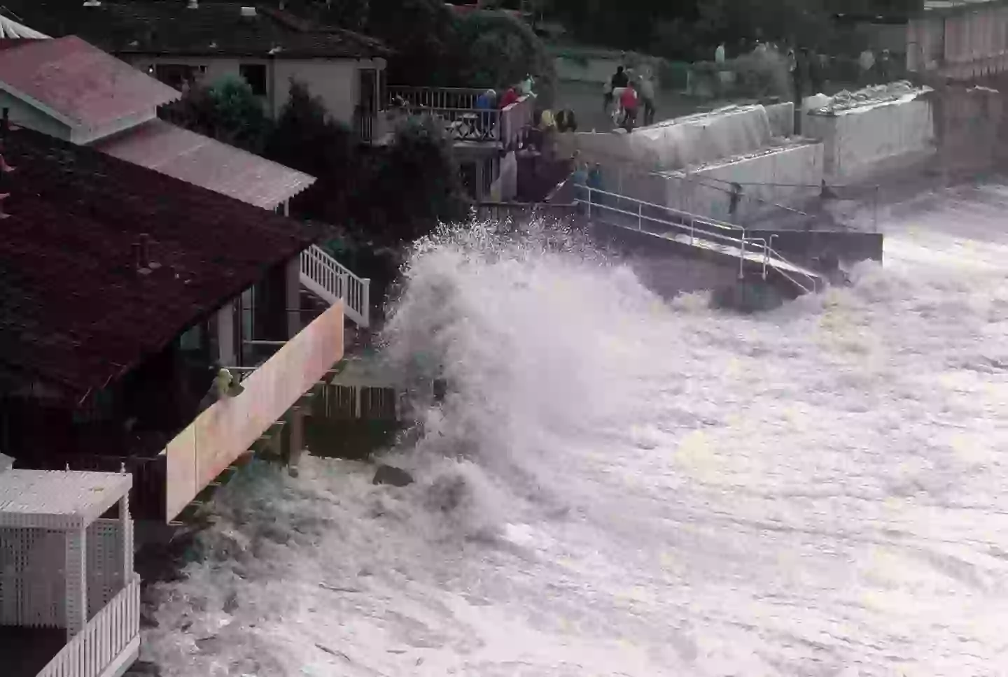
Environmental experts have revealed the three areas which would most affected in the event of a ‘mega-tsunami’.
For all the technological advances humans have made over the past couple of centuries, when it comes to the power of mother nature we’re still very much at her mercy.
From deadly hurricanes, tornadoes, earthquakes and volcanic eruptions, our reactions to environmental disasters is more about mitigation than prevention.
What scientists and experts can do is be on the lookout for warning signs at potential flashpoints and plan accordingly.
One such place is the Cascadia Subduction Zone, a 1,000km (620 mile) long region which is considered a major earthquake and tsunami hazard zone.
So where is the Cascadia Subduction Zone – and which places would be most impacted by an earthquake of tsunami in that region?
(Getty Stock Images)
Cascadia Subduction Zone explained
Located around 100–200km (70–100 miles) off the Pacific coast of North America, the Cascadia Subduction Zone is an area where two tectonic plates converge.
In this case, we have the Juan de Fuca, Explorer and Gorda plates sliding under the larger North American plate. The area spans the coast off northern California to British Columbia.
Cast your mind back to secondary school geography lessons and you’ll likely recall that two tectonic plates scraping alongside each other isn’t good news, as it can lead to earthquakes and (depending on the location) tsunamis.
How dangerous is the Cascadia Subduction Zone?
Experts have warned about the likelihood of another earthquake occurring along the Cascadia Subduction Zone, with their findings recently being published in the Proceedings of the National Academy of Sciences.
An earthquake in the region could lead to a mega-tsunami seeing waves as high as 1,000ft crashing into communities across the US.
The states of California, Washington and Oregon would likely face the largest impact, however, the impact could also reach as far as Alaska and Hawaii.
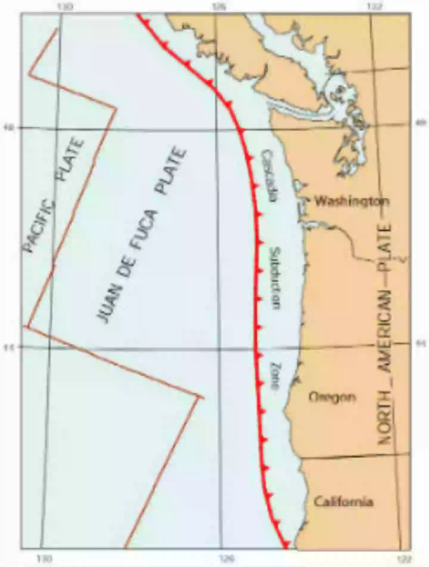
The location of the Cascadia Subduction Zone (Washington County Oregon Government)
If such an event were to happen, the Federal Emergency Management Agency (FEMA) estimates 13,000 fatalities while a further 27,000 could be injured.
This would make it the deadliest natural disaster in US history.
“The expansion of the coastal floodplain following a Cascadia subduction zone earthquake has not been previously quantified, and the impacts to land use could significantly increase the timeline to recovery,” Tina Dura, the lead author of the study, said.
1700 Cascadia earthquake
Geological records state that earthquakes occurring at a a magnitude 8.0 or greater typically happen around every 500 years or so.
The last recorded earthquake recorded in the region occurred in 1700, which means another earthquake grows more likely with each passing year.
Experts currently believe there is a 15 percent chance of a magnitude 8.0 or greater earthquake occurring within the next 30 years.
Supa Ant Fire Safety Ball as Fire Blanket for Home and Kitchen – Fire Protection Device for House, Office, Garage, Car
(as of October 27, 2025 18:42 GMT +00:00 - More infoProduct prices and availability are accurate as of the date/time indicated and are subject to change. Any price and availability information displayed on [relevant Amazon Site(s), as applicable] at the time of purchase will apply to the purchase of this product.)
RIVER OF GOODS Stained Glass Bird Accent Lamp - 8" W x 13.5" H - Tiffany Style Table Lamps for Home, Office Desk, Bedroom, Nightstand - Blue Jay Decor
$78.99 (as of October 27, 2025 18:42 GMT +00:00 - More infoProduct prices and availability are accurate as of the date/time indicated and are subject to change. Any price and availability information displayed on [relevant Amazon Site(s), as applicable] at the time of purchase will apply to the purchase of this product.)
RIVER OF GOODS LED Boho Ceiling Fan with Hand Woven Brown/Natural Rope - Macrame Knot Work and Hemp Rope Style Eclectic Cottage Decor - 52" L x 52" W - Rich Barnwood/Light Driftwood Fan Blades
$188.99 (as of October 27, 2025 18:42 GMT +00:00 - More infoProduct prices and availability are accurate as of the date/time indicated and are subject to change. Any price and availability information displayed on [relevant Amazon Site(s), as applicable] at the time of purchase will apply to the purchase of this product.)
Joking Hazard Enlarged Box Empty Box for Card Storage
$12.00 (as of October 27, 2025 18:42 GMT +00:00 - More infoProduct prices and availability are accurate as of the date/time indicated and are subject to change. Any price and availability information displayed on [relevant Amazon Site(s), as applicable] at the time of purchase will apply to the purchase of this product.)