NASA Uncovers Hidden Volcanic Secrets Buried Beneath the Sahara’s Endless Sands
Ever wonder what Earth looks like when it decides to throw a fiery tantrum? Well, NASA’s latest satellite eye-candy has captured a sizzling spectacle right in the heart of one of the planet’s hottest spots: the Sahara Desert. Yep, that sprawling, scorchingly brutal expanse famous for clocking temps as terrifying as 58°C just decided to flash us a million-year-old black lava field, fossilized and sprawled across North Africa like Mother Earth’s very own abstract art piece. Now, this isn’t just any snap—it’s a pixel-perfect mosaic crafted from nearly three years of NASA’s eagle-eyed satellites, piecing together the clearest, cloud-free glimpse of the Haruj volcanic field in central Libya—a volcanic oddball far from Earth’s usual fault-line drama. Curious how ancient lava quietly bubbles up without the giant eruptions we’re used to, reshaping landscapes slowly but surely? Pull up a chair, because this isn’t your typical geography lesson—it’s a fiery tale of heat, history, and a planet that never stops surprising us. LEARN MORE
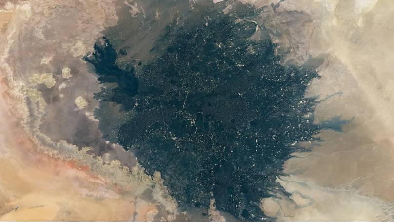
NASA’s satellite imagery has shown us some interesting views of our planet over the years, but a select few have offered us a fiery view of one of the hottest places on Earth.
Known for its extreme heat – with the highest temperature recorded as 58°C – the Sahara Desert is one of the most harsh environments in the world.
Images have emerged showing a giant black, fossilised lava field which is millions of years old, spewed across the North African desert.
How was the image made?
It has come from almost three years worth of NASA satellite imagery of the region, between July 2013 and April 2016.
The image is what is known as a ‘best pixel mosaic’. Essentially, it’s a combination of all the images put together into one and shows the ancient lava field in the middle of the desert.

The Sahara Desert is one of the hottest places on Earth (Frans Lemmens via Getty Images)
It was put together using a computer program which sorts through the images, pixel by pixel to make sure you end up with an image which is free from clouds, dust storms, or anything else which could obscure the pic.
What is the Haruj volcanic field?
The Haruj volcanic field covers a huge area in central Libya – where the images have been captured.
While most volcanos are located around the Earth’s fault lines, however, this particular volcanic fields isn’t located near any known fault lines.
Experts believe that the lava field were dragged up from the mantle by a surge of hot material, known as a mantle plume.
How big is the Haruj volcanic field?
The Haruj volcanic field covers a massive area in Libya of around 45,000 square kilometres.
Some experts have come to the conclusion that the volcanic field is actually made up of two separate volcanic fields, merging into one.
Evidence suggests that the north side of the volcanic field is made up of much older, ancient lava, whereas, the southern side of the field might have been created much more recently, which could indicate two separate fields and back this theory.

The volcanic fields have changed the desert landscape (Ulrich Hollmann via Getty Images)
Even if it is made up of two separate fields, due to its sheer size, and the fact it merges as one, most experts consider it to be a single volcanic field.
What does the Haruj Field tell us about Earth?
The Haruj volcanic field gives us an insight into how lava fields can be created, even without massive eruptions, or near fault lines.
Instead of volcanos changing the shape of the landscape around it, mantle plumes can instead slowly bubble up and change the environment around it.